Full Constellation & Frequency Anti-jamming L-Band
Technological Advantage
| • Full Constellation&Frequency GNSS Signal Solution | |
|
The device is equipped with a BDS/GPS/GLONASS/Galileo/QZSS Full Constellation & Frequency high-precision RTK solution. Additionally, the integrated Bynav REAL (Ransac Enhanced Advanced Location) GNSS positioning engine incorporates integrity monitoring, enhancing fault tolerance and fixed solution rate in urban areas. This is particularly beneficial in situations where multipath and interference conditions are present. The result is a more stable and accurate solution. |
|
|
• High-performance Multiple Interference Suppression
SAIF (Smart Advanced Interference Defense) is a high-performance multiple interference suppression technology with high AD quantization bits. It is built in and capable of handling different interferences, including single-frequency, multitone, sweeping, pulse, and narrowband, with an interference-signal ratio of 65 dBc. SAIF can effectively address vehicle anti-tracking equipment, radar/airport signal towers, and other sources of interference, thereby enhancing the availability and integrity of high-precision positioning in vehicle scenarios. |
|
| • L-Band*, CLAS*, B2b (PPP)* and E6 (HAS)* | |
|
The device is capable of receiving L-Band* SBAS signals and provides high-precision positioning in environments where conventional differential services or mobile communication services are unavailable. It supports BeiDou-3 B2b PPP* and E6 HAS* solutions, utilising the four-frequency signals from BeiDou and Galileo to significantly improve PPP convergence speed and enhance the availability of high-precision positioning. |
|
|
• Functional Safety ASIL B
The design is based on ISO 26262 ASIL B functional safety requirements. It incorporates a built-in functional safety GNSS SoC, namely Alice, and algorithm, which enables the provision of high-precision position, velocity and time data at the system level, thus facilitating the development of intelligent vehicles and autonomous driving technologies.
|
|
|
Feature |
|
|
» Independent Intellectual Property Rights |
|
|
» Full Constellations and Full Frequency(1507 Channels) |
|
|
» High-performance Anti-jamming* |
|
|
» Support Ethernet Port, Embedded SDK Differential Account, SupportgPTP Time Synchronization |
|
|
» AP Partition Design Ensures Stable and Reliable OTA Upgrades |
|
|
» Support System Self-check and Fault Diagnosis*
|
|
|
Application
|
|
 |
 |
|
Intelligent Driving |
Agriculture |
 |
 |
|
Drone |
Surveying |
 |
 |
|
Digital Construction |
Geological Monitoring |
|
Performance
|
|
|
Constellation:
|
GPS, BDS, GLO, GAL, QZSS, NavIC
|
| Number of Channel: |
1507
|
|
Tracking
|
|
|
L-Band*
|
3 channels, 1525~1559 MHz
|
|
BDS-2
|
B1I, B2I, B3I
|
|
BDS-3
|
B1I, B1C*, B2a, B2b*(PPP)
|
|
GPS
|
L1 C/A, L1C*, L2, L5
|
|
GLO
|
G1, G2
|
|
GAL
|
E1, E5a, E5b, E6*
|
|
QZSS
|
L1 C/A, L1C, L2, L5, L6*
|
|
NavIC
|
L5
|
|
SBAS*
|
L1 C/A
|
|
Anti-jamming*
|
|
|
Single-frequency, Multitone, Sweeping, Pulse,Narrowband;
|
|
|
Interference-Signal Ratio: 65 dBc
|
|
|
Interface
|
|
|
UART
|
×4
|
|
SPI*
|
×1
|
|
CAN FD
|
×2 |
|
ANT_DETECT
|
×1 |
|
PPS
|
×1 |
|
EVENT_IO
|
×5 |
|
RMII
|
×1 |
|
Horizontal Positioning Accuracy (RMS)1,2
|
|
| Single Point |
2.5 m
|
| RTK |
1.5 cm + 1 ppm
|
| Vertical Positioning Accuracy (RMS)1,2 |
|
| Single Point |
2.5 m
|
| RTK |
1.5 cm + 1 ppm
|
| Max. Output Rate |
|
| Dual-antenna GNSS Observation |
10 Hz
|
| Dual-antenna GNSS Position & Heading9 |
10 Hz
|
|
Time To First Fix
|
|
|
Cold Start 3,5
|
≤ 30 s
|
|
Hot Start 4,5
|
≤ 5 s
|
|
RTK Initialization1
|
≤ 5 s
|
|
Re-acquisition Time
|
≤ 1 s
|
|
Timing Accuracy (RMS)7
|
≤ 20 ns
|
|
Velocity Accuracy6
|
0.03 m/s
|
| RTK Solution Delay |
≤ 50 ms
|
|
Accuracy (RMS)
|
BDS
|
GPS | GLO | GAL |
|
B1I、B1C、L1C、L1 C/A、E1、G1 Pseudorange
|
10cm
|
10cm |
10cm |
10cm |
|
B1I、B1C、L1C、L1 C/A、E1、G1 Carrier Phase
|
1mm
|
1mm |
1mm |
1mm |
|
B2I、B2a、B2b、L5、E5a、E5b Pseudorange
|
10cm
|
10cm |
10cm |
10cm |
|
B2I、B2a、B2b、L5、E5a、E5b Carrier Phase
|
1mm |
1mm |
1mm |
1mm |
|
B3I、L2、G2 Pseudorange
|
10cm
|
10cm |
10cm |
10cm |
|
B3I、L2、G2 Carrier Phase
|
1mm
|
1mm |
1mm |
1mm |
Mechanical and Electrical
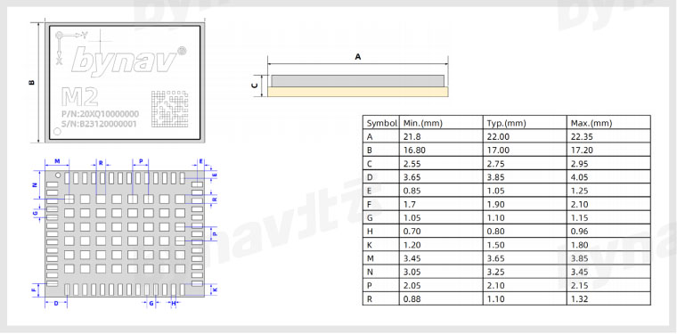
Size
16.0 x 21.0 x 2.6 mm
Package
48 pin LGA
Power Consumption8
530 mW
Power Supply Range
3.0~3.6 V
Environment and Certification
Operation Temperature10
-40 ℃ ~ +85 ℃
Storage Temperature11
-55 ℃ ~ +150 ℃
Humidity
95% Non-condensing
Vibration
JESD22-B103
Shock
JESD22-B110
IATF 16949*
ISO 26262 ASIL B*
AEC-Q104*
Note:
1. Typical value. Performance will be affected by GNSS status, satellite position, baseline length, multipath and other interferences;
2. Using a 1 km baseline and a receiver with good antenna performance, without considering possible errors due to antenna phase centre offset.
3. Typical value. There is no almanac, ephemeris and approximate position or time. or time.
5. -130dBm and more than 12 satellites are available.
6. Open sky without any obstruction, 99%@ static;
7. Optional. RF and antenna bias are not included.
8. Typical value. Antenna and peripheral power not included;
9. 20Hz is supported in special firmware;
10. There is an optional temperature range of -40℃ ~105℃;
11. There is an optional temperature range of -40℃ ~150℃;
* Optional, supported in dedicated firmware.
Mechanical Specification
